Deadly Deluge: The Lingering Impact of Tropical Depression Chantal in the Carolinas
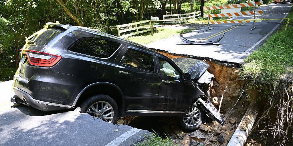
As the sun set on a seemingly typical Tuesday evening in Raleigh, North Carolina, storm clouds loomed ominously, fueled by the remnants of Tropical Depression Chantal. For many, the evening’s routine quickly transformed into a heart-stopping race against nature. In a neighborhood just outside the city, a local woman named Sarah hastily tried to navigate her car through what had transformed into a surging river of murky water. Moments later, she was trapped, a victim of the very storm systems predicted to wreak havoc once again.
The torrential rain that has saturated the Carolinas recently is not just a meteorological anomaly; it is part of a troubling pattern that climate scientists are increasingly linking to broader climatic shifts. Following Chantal, communities are grappling with the real and immediate dangers of flooding, even as forecasts threaten them with yet more heavy rain.
Unprecedented Flooding and Human Cost
At least four tragic deaths have been attributed to flooding exacerbated by Chantal this past week. A woman in Orange County was caught in the flood while driving to work; her body was later recovered by emergency responders. Similarly, two missing boaters on Jordan Lake met the same grim fate, and an elderly woman died when her vehicle was swept away by swift-moving waters. The scene is heart-wrenching, yet the recurring motif of natural disasters leaves communities in shock and disbelief.
“The thing to understand about these storms is that their impacts can be felt long after the rain stops,” explained Dr. Anne Mitchell, a climatologist at the University of North Carolina. “Excessive rain saturates the ground and raises water levels in rivers and streams, creating a threat of additional flooding even after the storm has passed.” Her research shows that areas previously affected by heavy rains are often more susceptible to subsequent events, amplifying the cycle of danger.
The Meteorological Landscape
This alarming return of severe thunderstorms and heavy downpours is predicted to impact areas from central North Carolina to the Interstate 95 corridor. The National Oceanic and Atmospheric Administration (NOAA) has issued a Level 3 out of 4 risk for excessive rainfall across significant portions of North Carolina and Virginia, including Richmond. The most recent weather advisories indicate that some affected regions could receive an additional three inches of rain this week alone.
According to meteorologist Marrisa Torres from FOX Weather, “The storms in this area are of particular concern because they tap into a high moisture content in the atmosphere. This leads to severe localized flooding that can occur almost instantaneously.” Moreover, with ground saturation already at critical levels, the risk of flash flooding remains acute.
A Broader Evidence of Climate Change
Experts unanimously agree that the increase in severe weather events can be correlated with climate change. A 2022 study conducted by the Environmental Protection Agency (EPA) found that the frequency of heavy rainfall events in the southeastern United States has risen by about 30% over the past 50 years. This uptick has many local officials sounding alarms over community preparedness.
- Increased rainfall intensity forecasts pose a significant risk to urban infrastructure.
- The vulnerability of older neighborhoods often built in flood-prone areas remains alarming.
- Emergency response plans need timely updates to account for new flooding risks.
“Communities need to rethink their emergency management strategies and adapt to new types of risks,” asserted Dr. Samuel Jenkins, an emergency management specialist at Duke University. “This requires not just awareness but also a proactive approach in public policy and infrastructure planning.”
Preparedness: A Community Responsibility
Preparedness goes beyond individual action; it requires robust systems. In a week where multiple states endured both deadly floods and widespread devastation, it becomes crucial to establish widespread community alerts and emergency protocols. Dr. Jenkins emphasized the importance of having backup systems in place. “People should not just rely on one source for weather information. A multi-channel communication strategy, especially involving emergency alerts, can save lives.”
Many residents often report being caught off guard due to insufficient warnings or late-night storms that offer little preparation time. Consequently, local governments have begun integrating more advanced weather systems to provide real-time information, helping mitigate risks at a community level.
As residents of affected areas begin to recover from this catastrophic weather event, one thing remains clear: the battle against nature is far from over. The risk posed by Tropical Depression Chantal and its lingering effects serves as a painful reminder for communities about the intersection of climate change, preparedness, and human life. Each season brings new unpredictability, demanding that front-line communities adapt swiftly to a deluge of challenges. Action is not merely an option; it is a necessity, one that needs to reverberate through streets and neighborhoods long after Chantal has faded from memory.