Understanding Sting Jets: Nature’s Hidden Fury
When we think of powerful storms, we often envision torrential rains and howling winds. However, hidden within certain large storm systems is a phenomenon known as a sting jet. This intriguing weather pattern represents a narrow, fast-moving stream of wind that can strike with remarkable intensity, often more forcefully than the surrounding storm itself. Much like the sting of a scorpion’s tail, sting jets can catch us off guard, unleashing violent gusts that directly impact the surface. So, what are these phenomena, and how do they form within extratropical cyclones?
The Formation of Sting Jets
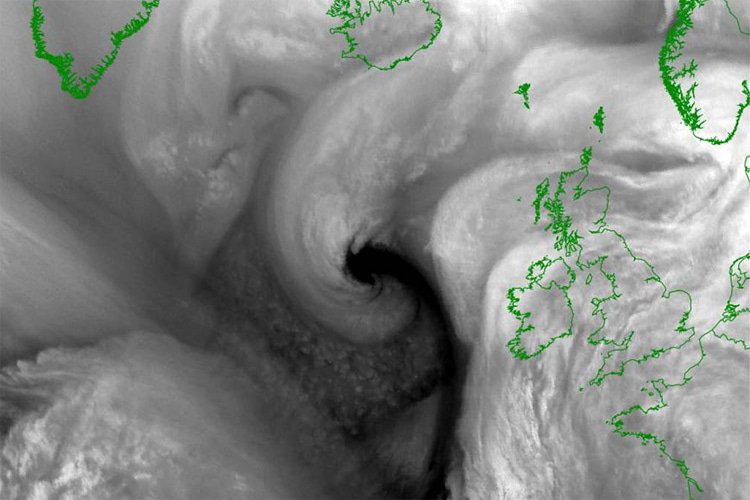
Sting jets primarily develop in specific patterns during the evolution of certain cyclones. These low-pressure weather systems, common in mid-latitude regions like western Europe and the North Atlantic, involve swirling zones of warm and cold air. In capable storms, powerful conveyor belts of warm rising air and cold sinking air energize the system. A vital stage occurs when changes in the cyclone’s structure create a gap between the cold and warm fronts—leading to a unique "back-bent" collar shape in the cloudy wrap around the storm’s center. Within this curled cloud formation, cool, dry air descends from several kilometers above ground. As precipitation falls, it evaporates and further cools the air, which, being denser, accelerates downward, effectively concentrating wind speeds into a sharp sting jet that strikes the surface below. The scorpion-like appearance of these cloud features inspired the term “sting jet.”
Locations and Timing of Sting Jets
Sting jets first garnered scientific recognition during the Great Storm of October 1987 in the UK and northern France, which inflicted catastrophic tree damage and destruction. Since then, research indicates that these jets frequently occur in powerful cyclones over the North Atlantic, especially during the autumn and winter months. Here, approximately 30-40% of the strongest storms exhibit conditions conducive to sting jets. The significant temperature contrasts and moisture in these regions create ideal circumstances for rapidly intensifying low-pressure systems. Recent studies suggest that sting jets may also manifest in strong storms over other ocean basins such as the North Pacific and the Southern Ocean, although they remain less studied. Intriguingly, evidence suggests that these features are more prevalent in the Northern Hemisphere compared to their Southern counterpart.
The Power of Sting Jets
The intensity of sting jets can be staggering, with wind speeds exceeding 100 miles per hour (about 160 kilometers per hour) in some cases. These localized jets can create extreme conditions, conjuring gusts that dramatically differ in intensity, even within a short distance—meaning one community might experience a devastating windstorm, while a neighboring area remains largely unaffected. Additionally, the phenomenon increases wave heights locally by generating vigorous surface winds over the ocean, impacting coastal regions.
Challenges in Early Detection
While meteorologists are adept at identifying broad storm systems, pinpointing sting jets presents a more formidable challenge. Due to their smaller scale and development in the mid-levels of the atmosphere, many global forecast models lack the detail necessary to detect these bursts of wind effectively. To improve accuracy, forecasters rely on high-resolution models and satellite images to identify critical signs, such as a hook-shaped cloud structure and zones of dry air intruding into the storm. They also evaluate atmospheric instability and mid-tropospheric conditions that favor descending air. Nonetheless, accurately predicting the location and intensity of sting jets remains complex and often unpredictable.
Impacts on People and Infrastructure
When a sting jet makes landfall, it can unleash sudden gusts that wreak havoc, leading to extensive property damage, uprooted trees, and disruptions in power and transportation services. Given the narrow bands in which these winds occur, emergency services frequently find themselves stretched thin, addressing multiple communities affected by damage simultaneously after a storm passes. Although predominantly recorded in Europe and the North Atlantic, ongoing global research is expanding the understanding of whether similar phenomena can arise in strong mid-latitude storms elsewhere around the world.
In conclusion, as advancements in atmospheric science and technology continue to evolve, accurate detection and forecasting of sting jets remain challenging but necessary. New satellite technologies and increasingly sophisticated weather models are enhancing our ability to issue timely warnings, but the innate complexities of these tiny, short-lived weather systems will likely keep them as one of meteorology’s most intricate puzzles for the foreseeable future. For ongoing updates on severe weather phenomena, consider exploring resources from NOAA and other meteorological institutions.
By strengthening our understanding of sting jets, society can better prepare for their extraordinary impact and enhance resilience against nature’s unpredictable fury.
This article is based on reporting from www.surfertoday.com.
The original version of the story can be found on their website.
Original Source:
www.surfertoday.com
Image Credit: www.surfertoday.com ·
View image


